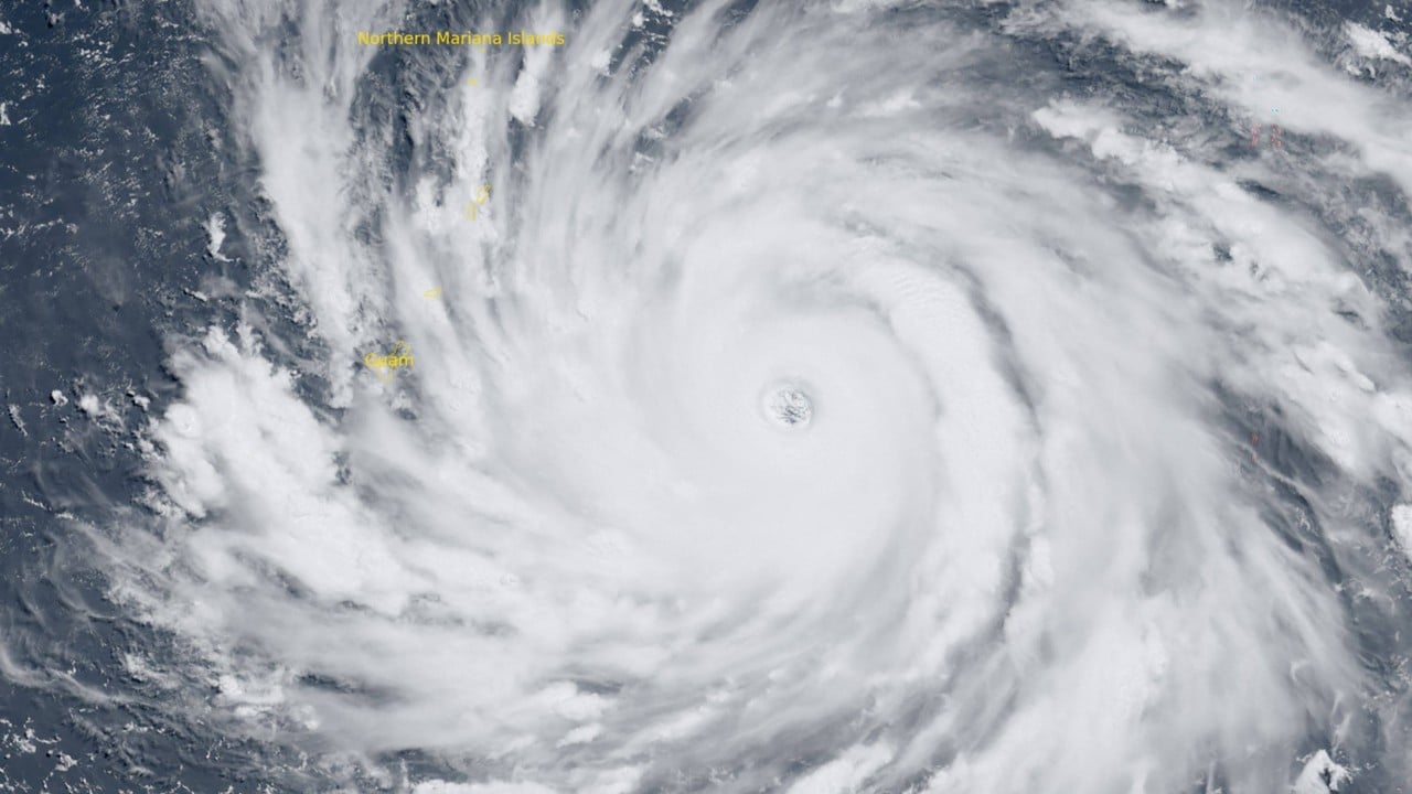
The western Pacific is hosting the scariest weather system on the planet right now, and it is heading straight for US soil. Super Typhoon Bavi has exploded into a Category 5-equivalent monster. It is currently churning westward through the ocean with sustained winds hitting 165 miles per hour and gusts screaming past 190 miles per hour. For the 210,000 residents living across Guam and the Commonwealth of the Northern Mariana Islands (CNMI), this isn't just another tropical storm notice. It's a terrifyingly familiar nightmare.
The National Weather Service (NWS) office in Guam issued blunt, uncompromising warnings. The window to prepare has slammed shut. Conditions are actively deteriorating. What makes Bavi uniquely dangerous isn't just its current 910 hPa central pressure or its massive 35-foot projected waves. It's the fact that these islands are still picking up the pieces from another catastrophic storm, Super Typhoon Sinlaku, which ripped through the exact same region just two months ago in mid-April.
Local meteorologist Landon Aydlett spoke from central Guam early Monday morning local time, visibly exhausted after tracking the storm for 24 straight hours. He didn't sugarcoat the situation. He called Bavi a "powerhouse" and warned of a grim outlook, noting that the island of Rota is likely positioned to take a direct hit from the absolute worst of the storm's core.
The Setup for Catastrophic Destruction
Bavi underwent what meteorologists call rapid intensification. The storm feasted on absurdly warm ocean waters. Sea surface temperatures in the region have been hovering around 29°C to 30°C (84°F to 86°F). This is essentially rocket fuel for tropical cyclones. This extreme warmth lines up with data from the European Union's Copernicus Marine Service, which confirmed that the world's oceans just endured their hottest June on record. Add a developing, powerful El Niño pattern into the mix, and you get the perfect recipe for an atmospheric beast.
The expected impacts across Guam, Rota, Tinian, and Saipan look brutal.
- Catastrophic Winds: Sustained winds of 165 mph will easily shred metal roofs, destroy frame houses, and turn loose outdoor items into lethal projectiles.
- Massive Storm Surge: Onshore winds are pushing a wall of water inland. Combined with tides, coastal inundation could reach 15 feet near the storm's center, swallowing coastal roads and low-lying neighborhoods.
- Torrential Rainfall: Forecasters are calling for 12 to 20 inches of rain. On these islands, that much water means immediate flash flooding and high-risk mudslides in hilly terrains.
Surviving the Waiting Game on the Ground
Walk through the streets of Saipan or Hagåtña right before the sky turns black, and you feel the collective anxiety. Businesses are entirely boarded up with thick plywood. Gas stations are locked down.
Local residents aren't naive about what is coming, but knowing what a Category 5 storm can do doesn't make the waiting any easier. Pinky Cubacub, a 55-year-old eatery owner in Guam, spent $500 on plywood just to board up her shop windows. She recently opened her business and admits she can't even afford to pay herself yet. Losing days of operation hurts deeply, but losing the structure entirely would be ruinous. Meanwhile, 51-year-old school bus driver Derma Soaladaob decided to abandon her concrete home for a hotel room. Even with solid concrete walls, she explained that the sheer howling noise of 160 mph winds is too psychologically damaging to endure alone.
The local infrastructure is under immense threat. When Sinlaku hit the Marianas in April, it knocked out power grid systems for tens of thousands of people, flipped cars, and caused the cargo ship MV Mariana to capsize, leaving five crew members missing. Bavi is packing even more punch.
The Reality of Island Isolation
When a storm this size targets a major continent, people pack their cars and drive inland for hundreds of miles. Island life doesn't offer that luxury. You cannot outrun a super typhoon on an island that is only 30 miles long. Your only option is to hunker down, trust your concrete construction, or move into a crowded public emergency shelter.
The Federal Emergency Management Agency (FEMA) has pre-staged massive amounts of supplies, including 1.1 million liters of water and 1.2 million meals, but real recovery takes months. Government officials like Guam Governor Lou Leon Guerrero have placed the territories into the highest emergency readiness states (COR 2), pleading with residents to stay off the roads entirely.
If you have family in the region or are tracking the storm's progress, understand that communication will likely cut out completely over the next 24 to 48 hours as cell towers and power lines succumb to the wind.
What to Do Right Now
The time for buying supplies or securing property has passed. If you are currently in Guam, Rota, Tinian, or Saipan, follow these immediate survival steps.
- Stay Inside the Core: Do not wander outside if the weather suddenly goes calm. That is the eye of the typhoon. The backside of the storm will hit instantly with equal fury from the opposite direction.
- Identify an Interior Room: Move to the most central room of your home, preferably a bathroom or closet without windows. Put as many walls between yourself and the outside as possible.
- Conserve Power and Water: Turn your smartphones to ultra-power-saving mode. Fill clean containers with drinking water immediately before municipal water systems potentially fail or become contaminated.